
![]()
|
Environment Agency Shoothill Gauge Map
|
Useful PDF Downloads:
The Flood Warning information on the left comes directly from the Environment Agency website. If a Flood Alert or Warning is shown, click on the appropriate symbol to obtain detailed information.
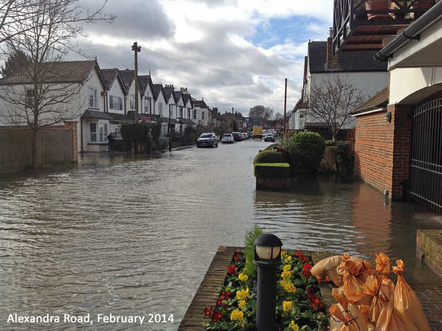
The River Level information on the left comes from the Environment Agency measuring station by Thames Ditton Island. For Thames Ditton, a river level approaching or over 6m AOD is critical and should result in a Flood Alert and Warning. In February 2014 the level reached 6.7m AOD and caused flooding.
Detailed information on the river levels and the Flood Warning process is available here.
Introduction Over the last 20 years, areas of Thames Ditton have been subject to or threatened by flooding: 3 times in 2003, in late 2013 - early 2014 and in late 2019 - early 2020. After the flooding in 2014 the Residents' Association established a Flood Group. The Group has worked closely with the Environment Agency, Elmbridge Borough Council and Thames Water to better understand the flood risk to residents and what can be done to mitigate the risk and deal with flooding when it happens again, as it inevitably will. |
The main achievements to date are:
- A major information gathering exercise has been undertaken to better understand the flood risk and what might be done to reduce it.
- A detailed table has been produced showing street height throughout the high risk area so that residents can relate it to the actual river flood level and see when to move cars etc.
- A Residents' Information Leaflet has been produced and distributed in the ‘high risk’ area.
- A Community Flood Plan is being produced and provided to Elmbridge Borough Council and the other relevant authorities. Copy to be added when completed.
- The Residents' Association website has been extended to include this section on Flooding.
- Thames Water have installed a non-return valve in the street drainage system for Alexandra Road and Queens Road that discharges directly into the Thames. This prevented street flooding in December 2019 and February 2020. Thames Water have also cleaned and repaired damaged drains.
- The Flood Group have held detailed discussions with the Environment Agency about the potential use of a Temporary Flood Barrier to protect the ‘High Risk’ area. This should lead to a scheme being proposed by the end of 2022 for use as required from the following winter. The scheme will be discussed with residents early in 2023. An outline of the Temporary Barrier is given here.
- The Flood Group have undertaken detailed height surveys along the river bank and other relevant locations in the ‘High Risk’ area and developed an outline potential route for a permanent flood barrier. The results are contained in a report here. The funding for the survey was obtained by the Flood Group from Elmbridge Borough Council.
- Following the survey, discussions have taken place with the Environment Agency about taking the outline design for a permanent barrier further to look at alternatives and the feasibility of a scheme. The Environment Agency have now allocated funding for this and a study will commence in April 2023 and aim to provide an initial report on options for discussion with residents in the summer 2023.
- Members of the Flood Group were invited by the Environment Agency and the Chairman of the local Flood Group to visit a permanent flood barrier scheme in Godalming. This is rather different to what would be required for Thames Ditton, but the Flood Group chairman was very positive about it and the high level of co-operation between the Environment Agency and their contractors with local residents. That scheme took five years from initial concept to completion.
The main area at risk from flooding is shown on the plan below. This has been provided by the Environment Agency and is the result of their latest modelling. It should be noted that this is currently not exactly the same as shown on their web site: https://flood-warning-information.service.gov.uk/long-term-flood-risk/map, but is in greater detail.
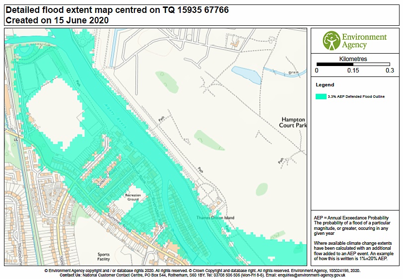 To get some perspective, in any year it is estimated that there is a 10% chance that there will be a flood as in 2014 and only a 3% chance of a flood affecting the whole ‘high risk’ area indicated above.
The meaning of 'High Risk' is explained in the Flood Warning Process Summary. The High Risk area shown on the plan is based upon current conditions and does not take into account the future impact of climate change. It is important that if you think that your property is in a High Risk area, you should sign up for flood warnings with the Environment Agency by calling Floodline: 0345 988 1188 or online at: https://www.fws.environment-agency.gov.uk/app/olr/register. It is recommended that you sign up for alerts and warnings for Thames Ditton Island rather than the mainland as currently the river levels used to trigger Island flood warnings are more relevant for mainland residents. The Environment Agency have recommended also signing up for Flood Warnings for the mainland in case some relevant information is provided with that warning.
The actual river levels at any time, as measured at Thames Ditton Island are given on the following web site: https://flood-warning-information.service.gov.uk/station/7246.
As far as residents potentially affected by an expected flood are concerned, the first thing that they will want to know is if and when they should move their cars and put in place any measures they may have to protect their property. The Flood Group have obtained detailed plans showing street heights and has divided the high risk areas into a number of zones, depending upon actual street height. Click here to see. So as not to cause complete chaos in the area if a couple of hundred cars need to be moved, the Sub-Committee are working with Elmbridge Borough Council to develop a plan both for appropriately alerting drivers when their cars should be moved, and to identify locations to move them to.
In the longer term, the Environment Agency are developing the River Thames Scheme to reduce flooding risk for sections of the Thames upstream of Teddington lock. This scheme is expected to have little effect on Thames Ditton itself. However, there are also proposals, mentioned above, for both temporary and permanent flood defences for Thames Ditton as an addition to the River Thames Scheme. The latest information about the main scheme is available here: https://www.gov.uk/government/publications/river-thames-scheme-reducing-flood-risk-from-datchet-to-teddington.
There is also the possibility for temporary flood barriers to be used as part of a national scheme to improve flood defences. This has identified 150 locations nationwide where they might be used, including Thames Ditton. Details of these schemes will be subject to detailed consultation with residents and the Sub-Committee will fully publicise the consultation events.
Residents should be aware that during flooding, there can be a significant tidal impact in Thames Ditton when the flood water is prevented from passing freely over the weir at Teddington by a high tide. This can add a short ‘spike’ in river height of up to 30cm - which would obviously worsen flood impact. The Environment Agency operated the Thames Barrier over 30 times in February 2014 to reduce this impact. With global warming it is estimated that the sea level may increase by 1m by 2100 and the Environment Agency has a Thames Estuary TE2100 plan to improve the defences up to Teddington. Details are available here: https://www.gov.uk/government/publications/thames-estuary-2100-te2100.
November 2022