
Environment Agency Consultation on the Update of the Lower Mole Flood Alleviation Scheme closed on 1st April
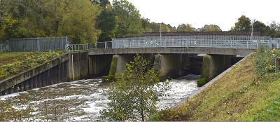
The Environment Agency reports that the Lower Mole Flood Alleviation Scheme, installed after the 1968 floods, is approaching the end of its design life and needs to be updated. Their consultation offers six options, with costs ranging up to £118 million. Some of the options would result in a substantial lowering of the water level in this part of the Rivers Mole and Ember.
Go to: https://www.lowermolefloodalleviationscheme.co.uk/ for more information on the options, and to access the consultation.
The TD & WG Residents' Association has made a submission to the Environment Agency stating the view that Option 3 is the only satisfactory option. This would maintain the existing water level and the same degree of flood risk protection. See below for the details explaining our reasoning.
TD & WG Residents' Association submission:
This submission is being made on behalf of the Thames Ditton & Weston Green Residents' Association. The EA tell us that "The scheme is now reaching the end of its design life and needs to be refurbished to maintain its standard of flood protection" . The EA has already undertaken regular upgrading works on the Ember Channel and this is exactly what taxpayers expect from a national agency.
We believe that much of the problem on the Rivers Mole and Ember is of the EA's making! Pennywort has been allowed to grow wild on major parts of the two rivers and it is reported that the Island Barn sluice became so clogged with the weed a couple of years ago that the main control gate collapsed and still lies on the riverbed with the river held back by a number of railway sleepers filling the gap left by the gate. This would be a relatively inexpensive undertaking to reinstall the gate, and the whole Ember infrastructure would be able to continue doing the job it was designed for.
There are numerous arguments that can justifiably be used to say that the River Ember should not be lowered, and here are just a few:
1. Lowering the water level will present a permanent danger to older people, pets and children, who use the towpath, because there is likely to be a greater than six foot drop from the capping beam to the river bed, which is likely to be exposed for most of the year.
2. The EA's "artistic" interpretation of what the riverbed and towpath will look like is completely impractical insofar as the need for the EA to access the pumping station located on Will O'The Wisp. This is the triangular piece of land, which was isolated by the rerouting of the Ember following the 1968 flood, and is only accessible via the towpath from the gate on Summer Road. If any major problem should occur with this pumping station, no vehicles could access the pumping station because there is no other way through the houses on Riverside and Summer Avenues and the EA representation shows it completely overgrown with shrubbery ( and out-of-scale boats!).
3. The original design of the flood alleviation scheme included a means to control the variable flow of the river such that a flood three times the volume of the 1968 flood could be managed and safely discharged into the Thames without undue pressure on the City of London and the Thames Barrier. If the River Ember is permanently lowered, there would be no means of protecting the City of London if a deluge similar to that of 1968 should occur at the same time as a North Sea Surge.
4. The River Ember is home to a very large variety of coarse fish including Carp, Chubb, Dace, Pike and other smaller varieties, which require a slow flow of water within which to thrive and breed. If the river level is reduced to the extent that is envisaged by the EA, none of the larger fish will be able to survive.
5. The River Ember is a regularly used means for residents to take their exercise on the river via rowing boat, sailboat, paddle board, motor boat or any number of recreational paraphernalia that would be completely unusable in just a trickle of water.
Lowering the river level permanently would be a serious inconvenience for river dwellers who have every right to fight to maintain their access and usage of the river. The use of ground anchors on the Ember Channel are to support the metal walls should the water level of the river drop below the land water table. Such an imbalance would put great stress on the metal walls that encase the Ember. The ground anchors were driven 8 metre deep into the adjoining land. Depending upon how close a property was to the new channel or the bend of the river dictated the amount of anchors needed to support the wall. If the anchors were to fail under stress, the walls of the Ember would tumble into the river, possibly destabilizing any adjoining land and property.